Google rolls out emergency alerts to millions more on Google Maps
- By Luke Stangel
Locally, those agencies include the California Highway Patrol, South Santa Clara County Fire District and Fremont police department.
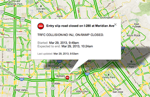
Google has steadily added new alerts to Maps. In January 2012, the company added alerts from the National Weather Service, U.S. Geological Survey and National Oceanic and Atmospheric Administration. The company also displays live AMBER alerts, traffic conditions and road hazards.
A major test of Google emergency alert system came in October during Hurricane Sandy. The company used its services to post evacuation routes, emergency shelters and other disaster-related information.
Next Article: SugarCRM
discloses $15.1M in options
We recommend
-
Korean restaurant to open in downtown Raleigh BizJournals
-
First Sprouts grocer to open in Katy in March BizJournals
-
St. Louis eatery named 'dining hot spot' BizJournals
From around the web
No comments:
Post a Comment